
Every story has a place.
Explore our reporting and places of note across Guyana. Hover over or tap anything on the map, choose a region, or combine the filters below.
Wildlife records
Most-recorded species
From the Global Biodiversity Information Facility (GBIF). Counts show where people have recorded wildlife, which follows roads, rivers and research stations, so they are not a measure of how common a species is.
 Story · Forests & carbon1.1M barrels a day, 85% forest: Can Guyana grow green?
Georgetown · Region 4 · Demerara-Mahaica
Story · Forests & carbon1.1M barrels a day, 85% forest: Can Guyana grow green?
Georgetown · Region 4 · Demerara-Mahaica
 Story · Biodiversity & wildlifeProtecting 30 Per Cent of Guyana: A “People Centered Way”?
Acarai–Rupununi corridor · Region 9 · Upper Takutu-Upper Essequibo
GeographyAnna Regina
Regional capital
Region 2 · Pomeroon-Supenaam
GeographyBartica
Regional capital
Region 7 · Cuyuni-Mazaruni
Blue economy and biodiversityBerbice River
River
Multiple · approximate
Infrastructure and developmentCheddi Jagan International Airport
International airport
Region 4 · Demerara-Mahaica
Blue economy and biodiversityDemerara River
River
Multiple · approximate
Blue economy and biodiversityEssequibo River
River
Multiple · approximate
Infrastructure and developmentEugene F Correia International Airport
International airport
Region 4 · Demerara-Mahaica
GeographyGeorgetown
Administrative centre
Region 4 · Demerara-Mahaica
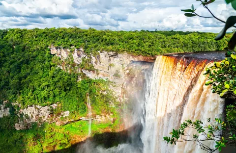
Blue economy and biodiversityKaieteur Falls
Waterfall
Region 8 · Potaro-Siparuni
Oil and gasLancetfish-1
Discovery well
Offshore
GeographyLethem
Regional capital
Region 9 · Upper Takutu-Upper Essequibo
GeographyLinden
Regional capital
Region 10 · Upper Demerara-Berbice
Oil and gasLiza-1
Discovery well
Offshore
GeographyNew Amsterdam
Regional capital
Region 6 · East Berbice-Corentyne
Oil and gasPayara-1
Discovery well
Offshore
Oil and gasRanger-1
Discovery well
Offshore
Oil and gasSailfin-1
Discovery well
Offshore
GeographyVreed-en-Hoop
Regional capital
Region 3 · Essequibo Islands-West Demerara
Story · Biodiversity & wildlifeProtecting 30 Per Cent of Guyana: A “People Centered Way”?
Acarai–Rupununi corridor · Region 9 · Upper Takutu-Upper Essequibo
GeographyAnna Regina
Regional capital
Region 2 · Pomeroon-Supenaam
GeographyBartica
Regional capital
Region 7 · Cuyuni-Mazaruni
Blue economy and biodiversityBerbice River
River
Multiple · approximate
Infrastructure and developmentCheddi Jagan International Airport
International airport
Region 4 · Demerara-Mahaica
Blue economy and biodiversityDemerara River
River
Multiple · approximate
Blue economy and biodiversityEssequibo River
River
Multiple · approximate
Infrastructure and developmentEugene F Correia International Airport
International airport
Region 4 · Demerara-Mahaica
GeographyGeorgetown
Administrative centre
Region 4 · Demerara-Mahaica
Blue economy and biodiversityKaieteur Falls
Waterfall
Region 8 · Potaro-Siparuni
Oil and gasLancetfish-1
Discovery well
Offshore
GeographyLethem
Regional capital
Region 9 · Upper Takutu-Upper Essequibo
GeographyLinden
Regional capital
Region 10 · Upper Demerara-Berbice
Oil and gasLiza-1
Discovery well
Offshore
GeographyNew Amsterdam
Regional capital
Region 6 · East Berbice-Corentyne
Oil and gasPayara-1
Discovery well
Offshore
Oil and gasRanger-1
Discovery well
Offshore
Oil and gasSailfin-1
Discovery well
Offshore
GeographyVreed-en-Hoop
Regional capital
Region 3 · Essequibo Islands-West Demerara
Wildlife records are observations and specimens shared through GBIF, the Global Biodiversity Information Facility, by museums, researchers, government agencies and members of the public. They show where species have been recorded, not their full range, and some sensitive species are shown at reduced detail. Locations marked approximate are reference points, not surveyed positions. Boundaries and lines are shown only where an official source is available. Sources are listed on each place’s page.